


(C) 2013 Sarah Brunel. This is an open access article distributed under the terms of the Creative Commons Attribution License 3.0 (CC-BY), which permits unrestricted use, distribution, and reproduction in any medium, provided the original author and source are credited.
For reference, use of the paginated PDF or printed version of this article is recommended.
Citation: Brunel S, Suffert M, Petter F, Baker R (2013) Interface between pest risk science and policy: the EPPO perspective. In: Kriticos DJ, Venette RC (Eds) Advancing risk assessment models to address climate change, economics and uncertainty. NeoBiota 18: 9–23. doi: 10.3897/neobiota.18.4049
The European and Mediterranean Plant Protection Organisation (EPPO) is an intergovernmental organization responsible for cooperation in plant protection in the European and Mediterranean region. It provides global distribution maps of pests, and intends to identify the areas at risk from new and emerging pests, in the framework of Pest Risk Analyses. EPPO has developed a decision-support scheme for Pest Risk Analysis (DSS) and a computer program (CAPRA) to assist pest risk analysts in running the decision-support scheme. Dedicated rating guidance and a Climatic Suitability Risk Mapping Decision-Support Scheme have recently been developed to guide assessors in identifying the potential area of establishment of a pest. All these tools have been developed taking into account both pest risk science available and needs of policy makers. The use of these tools and of mapping software are undertaken within the framework of EPPO Pest Risk Analyses, as illustrated through the examples of Thaumatotibia leucotreta (Lepidoptera) and Apriona germari (Coleoptera).
Pest Risk Analysis, pest risk mapping, modelling, Thaumatotibia leucotreta, Apriona germari
The European and Mediterranean Plant Protection Organization (EPPO) is the regional plant protection organization (RPPO) for Europe under the International Plant Protection Convention (IPPC). EPPO works with National Plant Protection Organizations (NPPOs) which are national bodies responsible for plant health policy. EPPO recommendations and Pest Risk Analyses (PRAs) may be used as basis for European Union or national regulations.
Founded in 1951, EPPO has grown from 15 original members to today’s 50 member countries, including nearly every country in the European and Mediterranean region.
EPPO’s objectives are to develop an international strategy against the introduction and spread of pests that damage cultivated and wild plants, in natural and agricultural ecosystems (including invasive alien plants); to encourage harmonization of phytosanitary regulations and all other areas of official plant protection action; to promote the use of modern, safe, and effective pest control methods; and to provide a documentation service on plant protection.
Such objectives are dealt with in part by providing regional maps on the distribution of pests, as well as by performing modelling to identify the probability of establishment of emerging pests in the EPPO region.
EPPO maintains the Plant Quarantine data Retrieval system (PQR), which provides detailed information on the geographical distribution and host plants of quarantine pests and of pests of phytosanitary concern. For each pest, it is possible to obtain lists of host plants, commodities able to act as pathways in international trade, details of geographical distribution with maps, and pictures of the pest at different stages as well as of symptoms of the pest. Conversely, it is also possible to query the database to obtain specific lists of pests, by stipulating the host species, the commodity, and the countries of interest. PQR contains general nomenclatural and taxonomic details on pests and hosts. In recent years, the database has been extended to cover invasive alien plants, including those having environmental impacts. All EPPO activities and recommendations on invasive alien plants can be consulted on its dedicated webpages (see http://www.eppo.int/INVASIVE_PLANTS/ias_plants.htm). PQR is used by risk assessors to obtain accurate information on the distribution of pests. Inspectors also make use of PQR to select pests to look for in different consignments according to their origins. The new PQR version can be downloaded free of charge from the EPPO website and includes world maps (see http://www.eppo.int/DATABASES/pqr/pqr.htm?utm_source=www.eppo.org&utm_medium=int_redirect).
These world maps display the known distribution of pests covered by the EPPO framework (pests recommended for regulation, quarantine pests and pests in the EPPO alert list). Representing such information at such a large scale is not a trivial task as national records, sub-national records and the fact that a species is transient need to be shown on the map. The distribution records are represented as in the map displayed in Figure 1 for Phytophthora ramorum. Countries where the species is recorded are represented in yellow, to which is added a red circle when the record is provided at the national scale, a red cross when the record is provided at the sub-national level, and a red triangle when the species is transient. Maps are dynamic and updated when new data are available. References are provided to support distribution records.
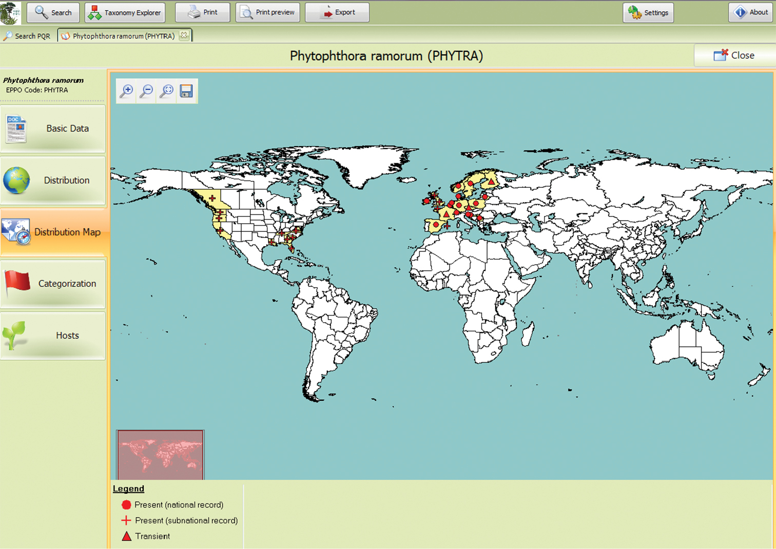
Global distribution of Phytophthora ramorum as shown by the EPPO Plant Quarantine Data Retrieval System.
In addition to mapping the global distribution of pests, EPPO models the potential distribution of pests when performing pest risk analyses.
One of EPPO’s main priorities is to prevent the introduction of dangerous pests (bacteria, fungi, insects, plants, viruses, etc.) from other parts of the world, and to limit their spread within the region should they be introduced. In recent years, trade networks have expanded and diversified, increasing the risks of introducing pests to new geographical areas. Measures adopted by countries to protect their territories from these introductions should be technically justified and an International Standard for Phytosanitary Measures (ISPM) on Pest Risk Analysis (PRA) (ISPM 11) has been developed by the IPPC. Since the 1990s, developments have taken place within EPPO. A Panel on PRA development has been created. EPPO has developed a decision-support scheme for Pest Risk Analysis (
In order to share costs and workload and to provide technical justification for the regulation of certain pests, EPPO conducts PRAs for the region. Since September 2005, the EPPO PRAs have been produced by dedicated Expert Working Groups for PRA. Approximately five pests (including one invasive alien plant) are evaluated by expert working groups every year. The composition of the Expert Working Groups includes experts on the pest, on the crop/habitat of concern, in socio-economics, on running the EPPO PRA scheme and on tools to help assess the potential distribution of the pest (e.g. geographical information systems (GIS) and CLIMEX (
EPPO stands at the interface between pest risk science and policy. EPPO’s procedures for the development and approval of standards and recommendations involve both risk assessors and risk managers at various steps of the process. This process facilitates communication between the two groups. This is illustrated in the way EPPO PRAs are performed and approved. After the scientists in the Expert Working Group have drafted the PRA, the document is reviewed by core members (experts nominated by EPPO countries’ plant protection organizations to review the PRA produced) to ensure the consistency in the use of the EPPO decision-support scheme for PRA. Once this review is done, the PRA is presented to the EPPO Panel on Phytosanitary Measures (composed of experts with a management background). This Panel reviews the PRA focusing on risk management options. During both reviews, the Expert Working Group is consulted to answer questions arising from the PRA. A report of the PRA is then produced and presented to the Working Party on Phytosanitary Regulation (composed of representatives of NPPOs, but not heads, see below) which makes proposals to the EPPO Council (composed of heads of NPPOs) that the pest should be recommended for regulation (or not) and subsequently added to the lists of species recommended for regulation as quarantine pests.
EPPO also collects information from experts during its workshops and conferences. Such data are then used within EPPO Panels to develop standards (e.g. national regulatory control systems), which are then reviewed and validated by risk managers and decision makers with the same groups as already mentioned above, i.e. the Panel on Phytosanitary Measures, Working Party and Council. EPPO’s role as an interface between science and policy was particularly clear when taking part in the PRATIQUE EU Research project to improve the EPPO Decision-Support Scheme. EPPO also ensures that the exchange of information is bidirectional. Thus, in the framework of PRATIQUE, a survey was conducted to seek the feedback of decision makers on Pest Risk Analysis in the EU Plant Health Standing Committee (e.g. on the usefulness of ratings, the decision makers’ perceptions of impacts, how to take time into account, how they would like climate change to be integrated in PRA, etc.). The outcomes of this survey were communicated to researchers so these could be taken into account when proposing new pest risk analysis methods.
Since 2011, the EPPO PRA scheme has been improved by integrating the outcomes of the European Research Project PRATIQUE (Enhancements of Pest Risk Analysis Techniques) which ran from 2008 to 2011 (
The new version of the EPPO Decision-Support Scheme (DSS) is freely available, including its computerized version named CAPRA (see
When assessing the probability of establishment of a pest, the assessor is requested to consider whether factors such as (i) host plants and suitable habitats, (ii) alternate hosts and suitable species, (iii) climatic suitability, (iv) competition and natural enemies, (v) the managed environment and (vi) protected cultivation are likely to have an influence on the limits of the area of potential establishment. Only the relevant factors are then considered to assess the limits and suitability of the endangered area.
For all these factors, guidance has been developed, and the relevant databases are listed in the CAPRA Datasets.
Emphasis has been given to assessing the climatic suitability of the environment in the PRA area. Rating guidance for climatic suitability is provided and links to maps useful in identifying the climates where the pest is present for comparison with the area under assessment are given. These include the CABI Crop Protection Compendium Pest Distribution and Climate Maps (http://www.cabi.org/cpc/), the Köppen-Geiger climate classification (
In addition, a Climatic Suitability Risk Mapping Decision-Support Scheme (
Stage 1: ‘Is it appropriate to map climatic suitability?’
Stage 1 is designed to ensure that risk assessors carefully consider whether it is appropriate to devote time and resources to mapping climatic suitability when the assessment is already clear-cut or the information available is likely to produce results that are difficult to interpret and are therefore unhelpful to the assessment of pest risk.
Stage 2: ‘What type of organism is being assessed and what are the key climatic factors affecting distribution?’
Stage 3: ‘How much reliable information is available on the key climatic factors affecting distribution?’
Stage 4: ‘What category of location data is available?’
Stages 2–4 are used to review the information available on a pest’s climatic responses and its distribution.
Stage 5: ‘Based on the type of organism, the information available on its climatic responses and the category of location data, how well is each climatic mapping method likely to perform?’
Stage 5 outlines the implications of using each method based on the information assembled in stages 2–4.
The new developments described above concerning the guidance to map the potential endangered area of a species were integrated into the EPPO DSS in 2011. The way the potential climatic suitability range has been assessed since these new developments is illustrated through two examples: Thaumatotibia leucotreta (Lepidoptera) and Apriona germari (Coleoptera).
Basic elements on Thaumatotibia leucotreta
Thaumatotibia leucotreta is a polyphagous pest and has been recorded on many hosts present in the EPPO region. Significant hosts include citrus species, cotton and maize. Damage is caused by larvae feeding in fruits, maize ears or cotton bolls. On citrus, the degree of damage is highly variable, but can reach up to 90%. The species is native and widespread in sub-Saharan Africa and also occurs on islands in the Atlantic and Indian Oceans (Madagascar, St. Helena, Cape Verde, Mauritius and Reunion). In the EPPO region, the species is only recorded in Israel.
Thaumatotibia leucotreta has 2–10 generations annually (Daiber 1980, Couilloud 1994, Begemann and Schoeman 1999). The number of generations is determined by several factors including temperature, food availability/quality, photoperiod, humidity, latitude and the effect of predators and diseases. In South Africa, during the summer, it can complete a generation in 45 days, while during the winter, development slows, although there is no actual diapause, and a generation takes about 100 days. In areas with a prolonged dry season, irrigation allows populations to build up to levels which can cause damage. For example, Thaumatotibia leucotreta was uncommon in Nigeria but became a major pest within 10 years of cotton irrigation being introduced into Nigeria in the 1960s (
All hosts are widely grown over the EPPO region, and hosts are therefore not a limiting factor to the establishment of the species. Mapping hosts is therefore insufficient. Except for climate, no other abiotic factors are likely to have an influence on the limits of the endangered area and were not considered further (see
Assessment of the climatic suitability of the EPPO region for Thaumatotibia leucotreta
For this assessment, it was decided to undertake a more detailed investigation than a visual comparison of global climate zones (i.e. the Köppen-Geiger climate classification, the World Hardiness Zones) to attempt to map the area of climatic suitability. The climatic suitability DSS (
It showed that, although Thaumatotibia leucotreta is present in the coastal plain of Israel, further investigation is needed to identify other areas that are climatically suitable in the EPPO region. Thaumatotibia leucotreta’s presence in the coastal plain of Israel indicates that some parts of the EPPO region are highly suitable climatically. The larval stage is protected within the fruit and the pupal stage may be in the soil but climate will still play a role in influencing survival. The species distribution is well known in sub-Saharan Africa. However, in the south-west of South Africa (Western Cape) the species is not considered to be native, there are only a few location records, and the southernmost limits to its distribution are set by the Indian and Atlantic Oceans. In addition, for year-round survival, the species needs fruits to be continuously available (although the species is polyphagous and can be found on alternate hosts such as nuts in the Cape).
Although the climatic suitability DSS indicated that the CLIMEX ‘Compare locations’ model (that predicts a species’ potential distribution based on known climatic responses and its current known distribution) would have been an appropriate task to undertake, this model was not run due to lack of time and because too little is known about the factors influencing winter survival. In addition, the distribution in South Africa is too strongly influenced by the presence of the sea and the requirement for a continuous food (fruit) supply to make it easy to infer the areas that are at the climatic limits of its distribution.
As a consequence, a simple rule based on diurnal temperatures (based on the difference between weekly maxima and minima) was adopted although it is recognised that this is based on very few locations (though these are considered to include the extremes in South Africa). Moreover, since there is uncertainty about the characteristics of the coldest winter that Thaumatotibia leucotreta can survive, this rule may identify only a minimum area of potential establishment when extrapolated to the EPPO region.
The maximum and minimum temperatures in South Africa and Israel (range limit of the species) were compared using the 1961-90 mean monthly minimum and maximum temperature interpolated to 10 minutes of latitude and longitude (
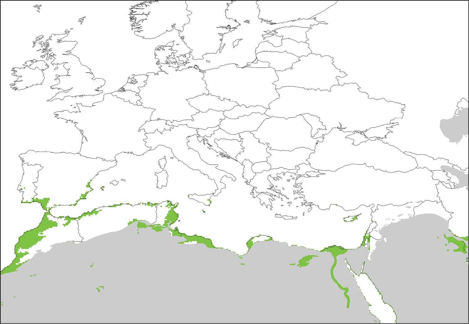
Non-desert areas of the EPPO region that are climatically suitable for Thaumatotibia leucotreta. This map is based on the relationship between maximum and minimum temperatures in the coldest month (July for the southern hemisphere and January for the northern hemisphere) based on: Tmin >= 1°C and Tmax >= 18°C, or Tmin >= 3°C and Tmax >= 15°C.
The potential for transient populations to develop during summer was explored. As shown in Figure 3, this analysis found that one generation (assuming eggs are laid early in the summer) is possible as far north as the Baltic coast of Sweden, Latvia and central England. In southern coastal Mediterranean climates, up to seven generations may be possible. In key citrus growing areas such as Valencia (Spain), five generations may be possible. In the Canary Islands and the Azores (not pictured in Figure 3), three to six generations are possible.
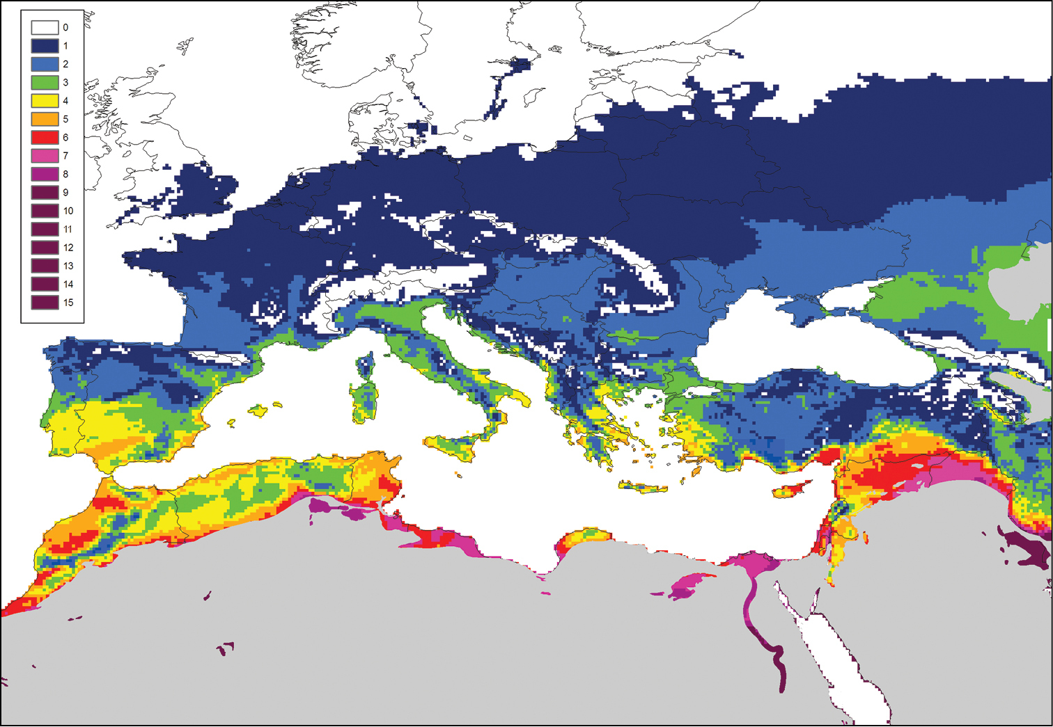
The number of generations for Thaumatotibia leucotreta possible in the EPPO region. This map is based on a minimum development threshold of 12°C and the number of degree days required for each generation of 433.
The tools provided by the EPPO DSS for assessing and mapping climatic suitability, simplified appropriately for the analysis (
Basic elements on Apriona germari
Apriona germari is an important pest of broadleaved trees. Seventy plant species of hosts are reported (from Betulaceae, Cornaceae, Ericaceae, Euphorbiaceae, Fabaceae, Fagaceae, Moraceae, Rosaceae, Salicaceae, Ulmaceae and other families). In its native area, this species causes significant economic damage (
Apriona germani is distributed in a large number of Asian countries (including Cambodia, China, India, Korea, Laos and Thailand). Although the species is believed to have originated in Asia, its exact native range is unknown. Apriona germari has been intercepted by countries in the EPPO region and in the USA on a number of occasions, and in particular in the Netherlands in 2008 and 2009, which triggered the production of a Dutch PRA (
The presence of hosts, the climate and the managed environment are factors which affect the extent of the area endangered by Apriona germari in the EPPO region. As large numbers of host species are of interest, global distribution maps of the main hosts, Ficus carica, Malus domestica and Pyrus spp., have been consulted and included in the PRA adapted from
Assessment of the climatic suitability of the EPPO region for Apriona germari
To evaluate the climatic suitability of the EPPO region, the assessment was strongly based on the existing Dutch CLIMEX ‘Compare Locations’ model (
In addition, maps of temperature accumulation in degree days have been compared for Asia and Europe and are shown in Figure 5.
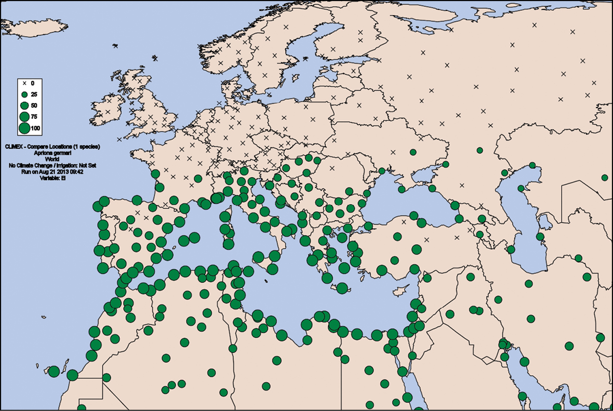
Potential distribution of Apriona germari in Europe based on a CLIMEX model with the hypothesis of a 3 year life cycle (1295 DD/year). The Ecoclimatic index (EI) indicates the climatic suitability for establishment. Crosses indicate unsuitable locations (EI=0). Green dots indicate the degree of climate suitability. The minimum threshold temperature for development in all models was 12 °C, based on
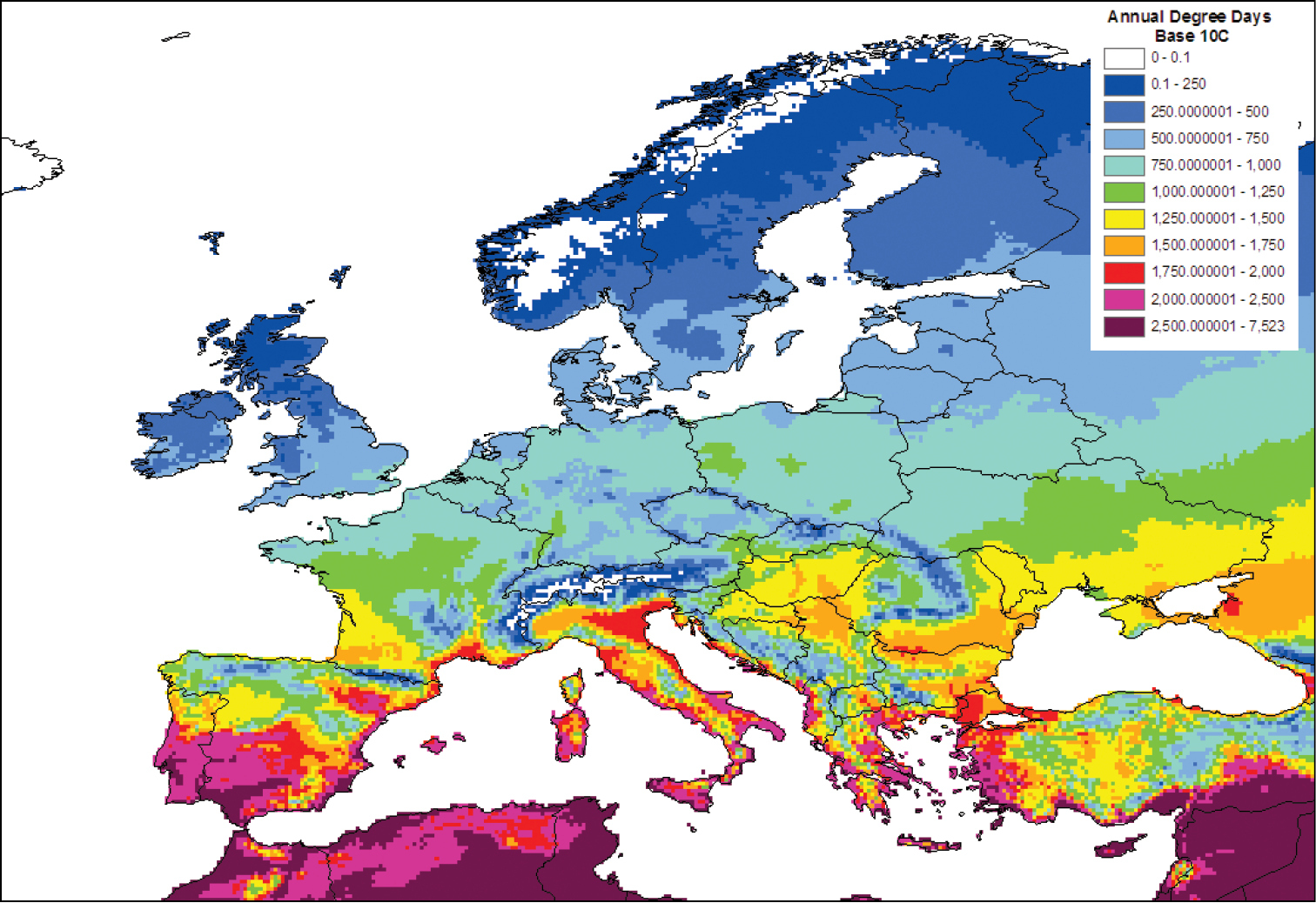
European Map of Temperature Accumulation (Degree Days). This map is based on a minimum threshold temperature for development of 10 °C, using 1961–90 monthly average maximum and minimum temperatures taken from the 10 minute latitude and longitude Climatic Research Unit database (
As for Thaumatotibia leucotreta, careful attention had been given to the assessment of the area of potential establishment by Apriona germari. Although hosts and climatic maps were not superimposed, the available maps have been gathered. All details of this analysis are presented in the Pest Risk Analysis for Apriona germari (
EPPO, as a regional plant protection organization, plays a major role in PRA and stands at the forefront of practical application in this field by integrating a detailed climatic mapping DSS in its PRA processes. The maps of pest risk analyses are used to support recommendations to member countries concerning the pests and phytosanitary measures that can be added to their regulations.
Mapping and modelling nevertheless remain very difficult exercises, limited by available expertise, time and data related to the species being assessed. It is thus essential for an assessor to be trained and to regularly perform climate studies. EPPO organises training courses to risk assessors to increase their modelling expertise in the EPPO region. Training courses have therefore been organized on CLIMEX in Spain and in France in 2008 and 2010 respectively. As CLIMEX demands a relatively high level of expertise, ‘Instructions for the Use and Interpretation of CLIMEX’ were developed by PRATIQUE (
EPPO Expert Working Groups for PRA take advantage of models that have already been performed on the pest being assessed. In the case of Apriona germani, the EPPO PRA was built on the Dutch PRA CLIMEX model. This highlights the need for existing models on pests to be shared and circulated so as to combine and not duplicate efforts. The development of a database centralizing existing publications and PRAs on pest climatic models would be of great relevance and use.
Furthermore, modelling is a highly technical task. While modellers may understand the limits of models and of the maps they produce, risk managers may interpret the maps differently and may get a false sense of certainty. Uncertainty is assessed for each question in the EPPO PRA scheme, including climatic suitability, and given a low, medium or high score, but no straightforward method for representing uncertainty in maps has been identified. Climatic requirements are very often mentioned as a key component of uncertainty in PRAs. This emphasizes the importance of considering the level of understanding of maps by readers and the need for further enhancements of risk communication.
In addition to the modelling of pest distributions in PRA, other sectors may lead to future developments in the field of mapping. Citizen science for the surveillance and reporting of pests and invasive alien species is gaining increased attention. At the European scale, the European Environment Agency intends to adapt the ‘Eye on Earth’ initiative to invasive alien species (http://www.eyeonearth.org/en-us/Pages/Home.aspx). Citizens would then be invited to provide data on the presence of particular invasive alien species which are already present in Europe and are sufficiently conspicuous and easy to identify. National projects have also been implemented with success. In Belgium, the Walloon region launched a citizen survey of the invasive alien plant Heracleum mantegazzianum. Heracleum mantegazzianum is the tallest Apiaceae in the world as it grows up to 3 m high. Data provided by citizens are then displayed on a Google map which can be zoomed (http://environnement.wallonie.be/berce/). Norway is also developing such a citizen project (
We wish to acknowledge the chairs and organizers of the International Pest Risk Mapping Workgroup, namely Rob Venette, Darren Kriticos, Frank Koch, Trond Rafoss, Wopke van der Werf, and Richard Baker. The work of the participants of the EPPO Expert Working Groups on Thaumatotibia leucotreta and Apriona germari was indispensable material for this article, and we thank them all. We would also like to thank the OECD Co-operative Research Programme for sponsoring the meeting.